|
 |
|
 |
 |
 |
|
|
 |
 |
 |
|
 |
|
 |
|
CARIS develops and supports rigorous, technologically advanced geomatics software. Our systems give value to spatial data and empower our customers with information that is meaningful. Integrity in business, recognition as experts, quality control, and dynamic customer relations are the distinguishing variables which ensure our ongoing success and that of our customers. CARIS was at the forefront of the movement toward computer-aided cartography and mapping in 1979 and is surging geomatics technology further with its open, flexible Internet and database-driven technologies.
Today, CARIS offers a robust line of spatial information management software for customers across land, marine and software development applications. Our product line enables customers to input, create and manage, and deliver consistently reliable spatial data information and products.
CARIS is a privately held Canadian company, with its head office in Fredericton, New Brunswick. The company has grown to include offices in the Netherlands and United States. Expansion plans continue as our client list continues to grow.Further support is achieved through an international network of distributors working to provide CARIS expertise and first-line support around the globe.
|
|
|
|
|
|
|
|
|
 |
|
|
CARIS BEAMS (Bathymetric Engineering And Management System) is designed to assist in the safe and effective management of ports and waterways. It serves not only as a survey management and storage system but also as an engineering application for various bathymetric analyses such as volume calculations, surface differences, and channel condition reports to name a few.
BEAMS is an effective presentation tool for displaying results on screen as well as publishing documents such as notices to mariners, work orders, and so on. In addition to document publishing, BEAMS data can also be web-enabled through CARIS PORTIS (Port Information System), the latest Web mapping solution for port and waterway management offered by CARIS. |
|
|
|
|
Character
|
|
 |
◎ |
The materials are dealt with fast. |
◎ |
Its user-friendly nature makes it accessible to most staff. |
◎ |
It can accept the form of many kinds of materials to input and export. |
◎ |
The materials can let many people share the materials and transmit the materials through the network. |
|
|
|
|
|
|
|
|
|
|
|
|
|
CARIS ChartServer is a server-based system enabling your web-browsing clients to view a catalogue of your charts and related products. The web is a logical medium for the supply of product information. However, the specialized nature of hydrographic products means that a web-solution for information distribution is beyond the scope of ordinary e-commerce systems.
ChartServer meets the demands of chart producers and distributors, such as Hydrographic Offices and Chart Agents, for a mechanism to optimize the web for browsing, ordering and downloading hydrographic products.
|
|
|
|
|
Character
|
|
 |
◎ |
Easy Database Administration. |
◎ |
Browse and Order. |
◎ |
Multiple Delivery Scenarios. |
◎ |
Database-driven. |
◎ |
Graphical Product Catalogue. |
◎ |
Specialized Product Support. |
◎ |
Highly Customizable. |
|
|
|
|
|
| |
|
|
|
|
|
|
|
CARIS Marine GIS is designed to provide a comprehensive spatial information management tool that addresses the GIS needs of a marine operational environment. All aspects of geo-marine requirement are addressed including data capture, cartographic representation to international standards (e.g. IHO), thematic layering and topological relationships, feature coding, data modeling and analysis, DTM generation and visualization, and plotting.
The CARIS Marine GIS is an effective spatial analysis tool that permits the creation of digital paper charts to IHO standards as well as the management of that same information for coastal zone mapping and analysis. All data contained within the CARIS Marine GIS can be further used for the creation and support of other user requirements such as IHO S-57 ENCs, Law of the Sea boundary delimitation, and NATO Additional Military Layer compilation. |
|
|
|
|
Character
|
|
 |
| ◎Data Capture |
◎Image and Vector Processing |
| ◎Data Integrity |
|
| ◎Database Analysis |
|
| ◎DTM Generation and Visualization |
|
|
|
|
|
|
|
|
|
|
|
|
|
|
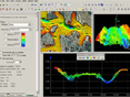
The HIPS and SIPS product is a comprehensive bathymetric data cleaning and validation tool integrated with powerful vector product creation. HIPS and SIPS can take the raw sounding data from ship to chart. Supporting over 40 industry standard sonar data formats, HIPS and SIPS can easily integrate into any workflow. Proven automated data cleaning filters and algorithms assist in today's high data volume environments. This, coupled with the ability to easily produce vector products such as contours and selected soundings, makes the software a powerful production tool. |
|
|
|
|
Character
|
|
 |
|
◎Process all auxiliary sensor data. |
|
◎Powerful and proven data processing. |
|
◎Automatic data filtering. |
| ◎Robust gridding techniques. |
|
◎Seamless area based cleaning. |
|
◎Powerful imagery processing. |
|
◎Target registration. |
|
◎High-resolution mosaic creation. |
|
◎Semi-automated Data cleaning with CUBE. |
|
◎Import data from many formats. |
|
◎Robust platform configuration. |
|
◎Rich background data support. |
|
◎Automated vector creation. |
|
◎Plot results. |
|
◎Produce full error estimates for all soundings. |
|
◎3D fly-through technology. |
|
◎Powerful quality control tools |
| |
|
|
|
|
|
| |
|
|
|
|
|
|
|
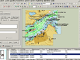
CARIS software systems embody a set of tools for the creation, editing, update and management of electronic chart production data: CARIS HOM for S-57 production which supports the IHO ENC, River/Inland Waterway and AML product specifications, and CARIS DOM for VPF production which supports DNCR, VMAP, and AML product specifications. |
|
|
|
|
Character
|
|
 |
| ◎Can watch sea map report and electronic sea map. |
| ◎Automatic batch treatment, accelerate working efficiency. |
| ◎Offer QA/QC tool, guarantee that data accord with IHO international standard. |
| ◎The strong data group maintains and manages tools. |
| ◎The friendly interface of user operates. |
| ◎Support different data forms. (DGN, DXF, E00, ASCII, GSF, raster, databases,etc.) |
| ◎Can combine with other CARIS products. |
|
|
|
|
|
| |
|
|
|
|
|
|
|
Implement a seamless database solution and eliminate data redundancy with CARIS Hydrographic Production Database (HPD). Using OracleR Spatial, HPD offers an integrated suite of products that can manage data in a seamless database, providing for simultaneous data processing and workflow by multiple users. Efficiency is maximized for data storage with features being stored only once, with the ability to create multiple representations for different products.
The HPD suite of products provides efficiency in maintaining source data and the production of multiple marine products from a single database.
Implement the HPD suite of products for production of S-57 ENCs and Paper Charts to IHO standards. The HPD product editors derive their products from the source data in the same database. Updates to source are carried automatically to multiple products. Product-specific features and customizations can be made without affecting the source features.
|
|
|
|
|
Character
|
|
 |
| ◎Use Oracle database system. |
| ◎Support different materials forms. |
|
|
|
|
|
| |
|
|
7.CARIS LOTS
(含LOTS Browser 4.0) |
|
|
|
|
|
|
Maximize Your Territorial Claims
This advanced desktop mapping software package has been specifically designed and developed to address any and all aspects of your coastal states' Law of the Sea applications.
Nations Around the Globe Choose CARIS LOTS
CARIS LOTS is in use in 40 Coastal States around the world, with more than 193 active licenses. |
|
|
|
|
Character
|
|
| |
| ◎Anyone can use the application. |
| ◎Addresses all aspects in a single software package. |
| ◎Continuously Enhanced and Updated. |
| ◎Start your application right out of the box. |
| ◎Rapidly Becoming the Industry Standard. |
|
|
|
|
|
| |
|
|
|
|
|
|
|
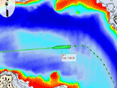
Weather information has now become a critical part of everyday life, much greater than just predicting the weather over the next few days.
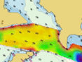
Oceanographic & forecast data now plays an important role in many major industries, whether it is to predict the course of an oil spill or to calculate the best path for the installation of a pipeline. Using CARIS MetOcean you can visualize near real time weather forecast information and observation data on the Internet. CARIS MetOcean displays both weather model and observation data geo-referenced with the rest of your GIS data layers. |
|
|
|
|
Character
|
|
|
| ◎Textual Forecast and Satellite Images. |
| ◎Select temporal window for "Time of Interest" |
| ◎High-resolution Plotting. |
| ◎Standard GIS Functionality. |
| ◎User Login Security. |
| ◎OGC Web Mapping Server. |
|
|
|
|
|
| |
|
|
|
|
|
|
|
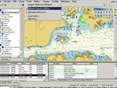
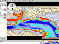
CARIS PORTIS is a Web mapping system designed with the port and waterway community in mind. PORTIS lets you access information from wherever you may be on virtually any PC connected to the Internet. Already used by several ports and waterway authorities around the world, PORTIS has proven to be an effective means to combine, and share the various spatial data resources you organization has access too. |
|
|
|
|
Character
|
|
 |
| ◎Multi-format base mapping. |
| ◎Real-time tracking of vessels. |
| ◎Standard GIS Functionality. |
| ◎Access your data the instant it's been updated. |
| ◎Easy maintenance. |
| ◎Bathymetric / Channel Analysis. |
| ◎Custom Views. |
|
|
|
|
|
| |
|
|
|
|
|
|
|
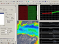
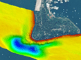
Bathy DataBASE software is used to create and management bathymetric surfaces generated from full density soundings. It allows users to validate, prepare and compile bathymetric data from multiple formats and sources to create product surfaces.
Moreover, Bathy DataBASE technology represents the very latest concepts in the creation and management of bathrymetric surfaces generated from full density soundings. Supercede functions allow for effective data compilation for maximum coverage of the seafloor. Users can focus on the management of the ?optimal? density of bathymetry data for the most functional and practical solution. Product surfaces can be used to generate contours and soundings. |
|
|
|
|
Character
|
|
 |
| ◎Managerial ability of databases. |
| ◎Support many kinds of map projection system. |
| ◎Support many kinds of materials. |
| ◎It can deal with many data of sea floor rapidly. |
|
|
|
|
|
| |
|
|
11.CARIS Spatial Fusion Enterprise(企業版) |
|
|
|
|
|
|
CARIS Spatial Fusion Enterprise (SFE) is used by public, private and non-profit organizations, with technical, social or economic development mandates. CARIS SFE delivers data for decision support to health, environmental management, natural resources, municipal, tourism, emergency services and business development organizations.
Small, medium or large, SFE provides a window for web mapping to novice, mid and experienced users over the internet or intranet with three easy-to-use deployment modules
。 |
|
|
|
|
Character
|
|
|
| ◎Effective use of GIS Staff |
| ◎Reduced cost of Ownership |
| ◎Corporate Database Integration. |
|
|
|
|
|
|
|